
Loveland Section
- Overview
- Akron
- Bedford
- Belle Valley
- Bowerston
- Burton
- Caesar Creek
- Defiance
- Delphos
- Loveland
- Massillon
- Medina
- Mogadore
- New Straitsville
- Norwalk
- Old Man's Cave
- Pemberville
- Road Fork
- St. Marys
- Scioto Trail
- Shawnee
- Sinking Spring
- Stockport
- Troy
- West Union
- Whipple
- Williamsburg

Trail Description
Abstract of BT through Hyde Park
Supervisor: Diane Wright
•
47.4 Total Miles / 47.4 Off Road Miles (100.0%)
Map Publication Date: September 2022
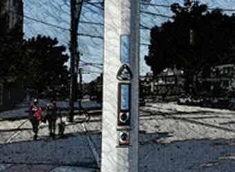
The Buckeye Trail, from it's southern terminus at the upper overlook in the northeast corner of Eden Park in Cincinnati, to the intersection of US 50 and Wooster Lane in Terrace Park is on urban and suburban streets. This section leads you past some wonderful examples of mansions and churches that were built in the late 19th and early 20th centuries. From the intersection of US 50 and Wooster Lane to the end of the Loveland Section, the Buckeye Trail follows the Little Miami Scenic Trail, a paved bike path located on abandoned Penn Central railroad right of way along the Little Miami River. The right of way is known as the Little Miami Scenic State Park.
Popular on hot summer days, the bike trail follows a rail bed first built in the 1840's as the Little Miami Railroad, named after the nearby river and not the size of the train! As the trail heads north, you pass through Camp Dennison, used as a Civil War camp by the Union Army. North of Loveland, the land gets less urban, though you can often hear the sounds of Kings Island amusement park near Foster. After passing through Morrow, the trail passes under the I-71 bridge and into the Caesar Creek section. The Fort Ancient prehistoric Indian earthworks and museum are adjacent to the trail near SR 350.
Both Loveland and Milford are designated BTA Trail Towns. The Loveland Section of the BT travels a very short distance through Milford, with the majority of the city lying in the Williamsburg Section.


Trail Alerts
- (3/20/24) The Little Miami Scenic Trail is closed in Morrow just past Point 20 at Front St. The Morrow bridge is being restored and a detour is marked for travelers. Cross Front St and follow the provided detour.
- (10/6/23) The Ohio Department of Natural Resources (ODNR) will replace the pedestrian bridge on the Little Miami Scenic Trail over O’Bannon Creek between Points 14 and 15 on the BT in Loveland. The bridge has closed and will open again at the end of May 2024. There is no ODNR or Loveland City designated detour at this time. The BTA is providing this as a detour. Traffic on the roads in this area is extremely heavy. Please use all crosswalks and sidewalks when available. Total length of this detour is .45 mi.
- Point 14 - Little Miami Scenic Trail (LMST) at Loveland Ave in Loveland.
- Cross Loveland Ave using the pedestrian traffic control signals.
- Turn right (slightly ESE) onto walkway along Loveland Ave.
- Pass Railroad Ave on left, cross RR tracks, to Second St (SR 48)
- Cross Second St on crosswalk, turn left (N) onto sidewalk along Second St
- Pass unnamed street on right, cross RR tracks on right side of first crossing gate to sidewalk. Continue N and then NE to Lyons Rd
- Cross Second St (SR 48)(NW) onto the south side of Lyons Rd, pass Maple Ave on left, continue to LMST
- Turn right (N) onto LMST and continue on to Point 15.
Map Updates
- (10/20/22) The BTA Map Committee announces that an updated map is now available for the Loveland Section. This becomes the September 2022 edition and inlcudes the updates referenced below. The new map is available through the BTA Store.
- (12/3/20) While enhancing the BTA's information in the Guthook app, Andy Niekamp discovered that three links cited in the Loveland Edition of March 2012 are incorrect. He kindly provided us with the updated links where possible.
The first problem link is cited in the text under Pt 1. The last sentence in the first paragraph refers to a wonderful brochure which, unfortunately, is unavailable. Remove the sentence that reads, “See www.marcy.com/segway/Segway_Tours_Brochure.pdf for many other features of this interesting park.” from your map.
The second problem link is cited in the text under Pt 8. In Line 8 of the first paragraph, in the sentence that begins, “For details,” please replace the inactive link with the current link, https://ohiodnr.gov/wps/portal/gov/odnr/go-and-do/plan-a-visit/find-a-property/little-miami-state-park .
The third problem link begins in Line 3. Please update the link shown in your map to https://www.milfordohio.org/departments/public_works_department/parks_and_recreation/index.php - (6/19/18) CAMPING Point 10 - Camping available in Milford is in nearby Jim Terrell Park and Riverside II Park. A permit is required and has a fee. The link to the permit has changed. See: http://www.milfordohio.org/Departments/Parks%20&%20Recreation/ParkCampingPermit.pdf .
- (11/10/2017) This note updates your Loveland Map Edition of March 2012.
1. There has been a route change within Cincinnati which changes the text between Points 2 and 4. The location of Point 3 has been moved. There has been no change in the length of the Section. See the log below.
2. Near Loveland, Bruce’s Canoe Livery is no longer a possible camping location. However, a new primitive campsite has been added nearby. Follow the Little Miami Scenic Trail north from Nesbit Park in Loveland across both O’Bannon Creek and LyonsAve/Cones Road. This location, 39° 16.400' N, 84° 15.372' W, is about ¼ mile north of Nisbet Park. The campsite is free of charge. Simply provide notice of your stay in advance by emailing your name, dates of occupancy and contact information to
| CW | CCW | Pt | |
|---|---|---|---|
| 0.3 E |
45.6 SW |
2 | Eden Park Dr at Park Ave and Victory Pkwy Turn E onto Victory Pkwy. Stay on sidewalk on right side of Victory Pkwy as it turns N through mixed business/residential neighborhoods. After 0.4 mi, turn E onto E McMillan St. After 0.2 mi, exit E Mc Millan St NE onto the sidewalk along the right side of Woodburn Ave. |
| 1.3 E |
44.6 SW |
3 | Woodburn Ave at Madison Rd Turn E onto sidewalk along right side of Madison Rd past numerous parks, including Owl’s Nest Park (0.7 mi), and other facilities. Madison Rd generally trends NE. |
| 3.0 E |
42.9 NW |
4 | Madison Ave at Erie Ave Turn E onto Erie Ave past PO: 45208 in 5 blocks. Return to the trail log as written in the Loveland Section Map Edition of March 2012 |
Trail Towns
Loveland
The City of Loveland was formally designated as a Buckeye Trail Town on April 22, 2017. The City of Loveland is proud of the Trail Town designation and welcomes all the many hikers and cyclists to our wonderful downtown. The Little Miami Scenic Bike Trail runs through the heart of Downtown Loveland with a wide variety of businesses and direct access to Nisbet Park. Nisbet Park includes restrooms and picnic shelters. Approximately 1000 feet north of Nisbet Park is a primitive campsite location. The campsite is free of charge we simply request notification of your stay in advance by emailing your name, dates and contact information to
Milford
Milford was the first Buckeye Trail Town and is an ideal setting for day hikers and backpackers. The Loveland Section passes through Milford for a very short distance on the west side of the city where Rt 50 and Rt 126 meet. Milford offers a variety of features including a charming main street, hiker friendly shops and restaurants, attractive architecture, several camping locations for through hikers, and an interesting history. The trail follows sidewalks through town, permitting access to the above mentioned features.
Section Blogs
- (1/12/14) Loveland Section Blog - Provided by Diane Wright, Section Supervisor - The writer T.S. Eliot wrote, “What we call the beginning is often the end. And to make an end is to make a beginning. The end is where we start from,” and the Southern Terminus of the Buckeye Trail illustrates that quote beautifully. Many people begin or end their Buckeye Trail journey at the Southern Terminus sign, located at the Spencer Overlook at Cincinnati’s Eden Park. The urban “leg” of the trail between Milford and Eden Park offers dozens of interesting section hike possibilities: cafe to cafe, or brewery to brewery, and the rare opportunity to shuttle using public transportation through the Southern Ohio Regional Transit Authority (SORTA). If you are a thru-hiker or section hiker getting ready to finish the trail in the Loveland Section, please reach out to the section supervisor so we can celebrate with you!
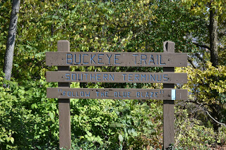 Photo Courtesy of Jennifer Koester |
- (5/21/23) Provided by Victoria Livingston, BTA hiker. Join Victoria and her husband Dave, as they hike the never ending Loveland Section and finish their 200 mile mark on the BT. Follow their adventure here on the rainy BT that day.
- (1/18/24) Victoria Livingston, BTA hiker, and her husband Dave, hike another portion of the Loveland Section. "We absolutely loved this stretch of the Buckeye Trail!" Begin at Eden Park in Cincinnati and stroll past historic houses and whimsical artwork. Follow their stroll here to discover a secret gem in Cincinnati.