


Photo: Darryl Smith
Short Hikes on the Buckeye Trail
Fort Hill
Darryl Smith
Distance: Six mile loop, with options to lengthen or shorten the mileage.
Hiking time: Three to four hours.
Directions: Fort Hill, 13614 Fort Hill Road, Hillsboro, OH 45133
Fort Hill is located off of State Route 41 on Township Road 256, five miles north of Sinking Springs and three miles south of Cynthiana in Highland County.
Parking & restrooms: There are two parking lots, the main lot easily holds up to fifty vehicles, and there is a smaller lot at the museum. Latrine toilets on site.
Maps: A good map is highly recommended. Obtain the Sinking Spring Section map from the Buckeye Trail Association. A Fort Hill Trail Map is also available at https://arcofappalachia.org/fort-hill/.
Fort Hill State Memorial is a nature preserve containing one of the best preserved Indian hilltop enclosures in North America. The Hopewell Indians (100 B.C.-A.D. 500) constructed the 1-1/2 mile long earthwork hilltop enclosure as well as at least two ceremonial buildings and probably a village in the Brush creek Valley. Lying at the western edge of the Allegheny Plateau, immediately south of the glacial boundary, this hilly area contains an impressive diversity of bedrock, soils, flora, and fauna. There are 11 miles of hiking trails at the 1,200-acre preserve as well as a picnic area.
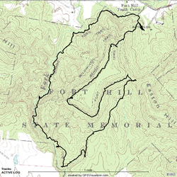
From the trailhead sign, climb gently along the Gorge/Fort Trails (which is also the Buckeye Trail). Within a minute of hiking you will come to a fork in the trail. The Fort Trail continues left up the steep incline to the top of Fort Hill, while the Gorge Trail pushes forward. The more challenging route is up the Fort Trail, which climbs steeply 400 feet in elevation. The easier path is the take the Gorge Trail. This hike is described from the more difficult direction.
Once you have made the left turn you will climb at times gradually, and at times very steeply, to the top of Fort Hill. The ancient walls that circumnavigate the top of Fort Hill were built two thousand years ago, are six to fifteen feet in height, and circle the hill plateau for one and a half miles. There are thirty-three gaps in the walls, and the area on top of the hill is about forty acres in size.
After your steep climb you come to a bit of an overlook to the right and if your heart is racing, a much deserved short break. From the overlook the trail heads left, running easily on top of the plateau. This area is covered in paw paw and mayapple in the spring and is a rather enjoyable walk no matter what the season.
At the end of this easy walk you will come to the south wall and a steep descent. Be careful here as small rocks, tree roots, and wet leaves can make footing tricky. At the bottom of this one hundred foot drop, the trail goes left and walks along a benched area. The walls and gaps of the fort can be seen to your upper left as you hike along. Shortly you will come to a trail junction as the Gorge Trail rejoins the Fort Trail at the point. You can take the Gorge Trail to the right and reduce your hike by nearly a mile, but I would recommend pushing on along the Fort Trail as the best option. After awhile, a trail appears on a saddle to the right (watch for an old red triangle nailed to a tree about eight feet high on your left). This is the newly created Connector Trail. If you go straight you will return to the picnic and parking lot area and complete a two mile hike. However, for this six mile loop take a sharp right onto the Connector Trail and walk a few hundred yards along the saddle that connects Fort Hill and Easton Hill. You will come to another trail intersection – this is the Deer Trail coming up from the parking lot (near the shelter). Take a sharp right turn onto the Deer Trail and descend along this narrow and slanted path. Use a bit of caution here. As you climb down, you will begin to notice a beautiful wooded area. The Deer Trail has an abundance of paw paw, which makes spring and fall hiking very nice indeed. The narrow path gives way to a wider avenue, but the woods are just as nice.
After a bit of distance, you will come to another trail intersection. This is the Gorge Trail coming down from the right from the intersection previously mentioned. A right turn here will lead you .3 miles upward to the intersection with the Fort Trail, but our path is to the left, along a wide avenue. After a short easy walk, the Gorge Trail makes a sharp right turn where it joins with the Buckeye Trail coming in from the south. From this point on you will be on both the Gorge and Buckeye Trails, so watch for blue blazes for the remainder of your hike. Descend a bit, and make a turn to the west, and enter an area along a seasonal creek. This is Spring Creek, and as you walk along notice the rock outcroppings appearing on the left. Keep your eye open along these formations and you will see the Spring Creek Arch across the ravine. These rock outcroppings continue as Spring Creek joins Baker Fork. Follow the trail to the right and climb a set of stairs (use caution – as with all wooden stairs, they can be very slippery when wet or covered with leaves). You will descend back down into gorge after a short period of time. From here until the end of the hike, the trail will be narrow and slanted in places, so use caution and be sure of your footing. You are now walking within the heart of the gorge along Baker Fork as you head north along the western side of Fort Hill. There are rare plants to be found here . . . yellow lady-slippers, orchids, and other plant life all seem to enjoy Fort Hill’s unique biosphere.
At the bottom of one of your descents there will be another trail intersection. This is where Canby Mountain Lover’s Trail heads to the left and crosses Baker Fork. The crossings can be deep and hazardous after rain- or snow-falls, but the Canby Mountain Lover’s Trail offers some solitude and two more good climbs for those wanting more cardio. Regardless if you take the Canby Mountain Lover’s or the Gorge Trail, you will want to walk left of the creek at this point. Directly across from you is Keyhole Arch. It is really more of a tunnel than an arch as it is far deeper than it is wide, but it is still a rather interesting feature nonetheless. Canby Mountain Lover’s Trail winds left to the south at this point before it crosses Baker Fork, climbs the opposing ridge, and crosses on the ridge over Keyhole Arch.
Back on the Gorge Trail, you will meander up and down along the gorge, and climb up a third set of stairs. When you get to the top of these stairs, look directly left across the gorge and you will see the Y-Arch, an arch that has one front opening and two rear ones. This arch is much better seen in the late fall through early spring, when leaves are absent to block your view. Fort Hill has the highest concentration of arches within the State of Ohio, but only a few can be seen from the trail system.
Eventually you will leave Baker Fork for a bit, and head through an open area that has a cabin. According to Robert Pond’s Follow the Blue Blazes this cabin was the home of a former freed slave. It makes a nice break location, but be aware from this point you only have one mile before returning to the parking lot.
Heading north from the cabin you will come to another trail intersection where Canby Mountain Lover’s Trail joins back with the Gorge Trail. Take a sharp right turn to stay on the Gorge Trail (if you cross the footbridge you are on the correct path). You will soon have Baker Fork as your companion once again, and after two short and moderately steep climbs you will come back to the first intersection described on this hike. Go straight to return to your car, or turn right to tackle Fort Hill again!
NOTE: The trails are closed for Ohio Historical Society's annual deer hunting for several days in the late fall/early winter. Dates are posted at https://arcofappalachia.org/fort-hill/ as soon as they are made public.
Photo: Darryl Smith