


Short Hikes on the Buckeye Trail . . .
Old Man's Cave to Ash Cave
Deposits in an ancient sea first formed about 350 million years
ago. Subsequent uplifting, weathering and erosion have
reuslted in this rugged terrain. Photo: Connie Pond.
Bob and Connie Pond
Distance: 6 or 10 miles
Hiking time: 3 to 6 hours
Description: This hike makes use of the Buckeye Trail
and the white blazed Bypass Bridle Trail to create a loop hike.
Two options offer either a 6 mile or 10 mile round trip. The hike
starts on the Buckeye Trail where it crosses SR 664/374 near Old
Man's Cave and follows the BT until it crosses SR 56. Here hikers
switch to the Bridle Trail for the return trip.
This is a moderately hard hike down in the most beautiful gorge
in Ohio. You will be walking under, over and around magnificent
rock formations. You will see the twisted remains of the violent
flooding destruction from 1997. All around, the stately hemlocks
shelter you from the cold winds in winter and provide cool shade
in the summer.
Directions: From Columbus, follow US 33 southeast to SR 374. Follow SR 374 south to the BT. From Athens, follow US 33 northwest to SR 664. Follow SR 664 south to the BT.
Parking & restrooms: Park in the parking lot. There are restrooms located across the road and to the right from the parking area. There is also a snack bar open during the summer.
Maps: A good map is highly recommended. Obtain the Old Man's Cave Section map from the Buckeye Trail Association.
Old Man’s Cave is a scenic attraction of Hocking Hills
State Park. The park is actually composed of six separate areas
and encompasses some of the most diverse and fascinating terrain
in the state. The area is administered by the Ohio Department of
Natural Resource’s Division of Parks and Recreation.
1. Begin the hike on the south side of SR 374/664, just
west of the campground entrance. Following the Blue Blazes, cross
over from the parking lot to the northernmost part of the park
area. You will see a stone bridge spanning a small creek
that falls into the gorge. On this bridge, you will
see a plaque dedicating this portion of the BT to the memory of
Emma "Grandma" Gatewood, a founding member of the
Buckeye Trail Association, and three-time Appalachian Trail
thru-hiker.
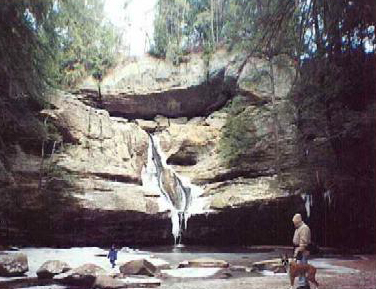
The beauty of Cedar Falls.
Photo: Connie Pond
After crossing the bridge, bear to the right and descend into the gorge on the stairs. Because of the 1997 flooding, a number of bridges were lost and you will have to do some stream fording. The water will not be higher than then toe level and often, resourceful hikers have placed logs for walking upon. Waterproof shoes, especially in the winter are a must.
2. The Buckeye Trail continues along a scenic gorge and creek to its confluence with Queer Creek, which it turns and follows upstream. Along the way, be sure to climb into Old Man's Cave, a huge rock shelter named after a hermit rumored to live here after the Civil War. Look also for Devil's Bathtub, Sphinx Head and Upper and Lower Falls.
3. Reach the parking area for Cedar Falls at 3.0 miles. Early settlers mistook the hemlock on adjacent cliffs for cedar, hence the name of the falls. Continue west on State Forest road and bridle trail, through orange gate and onto a footpath.
A shorter 6 mile hike is possible by leaving parking area at Cedar Falls on the road to SR 374. Turn left along SR374 and follow a short distance until the white blazed bridle trail crosses (TR 270). Turn left on the bridle trail and follow from point 7 below.
4. Cross Chapel Ridge Rd at 4.1 miles. BT continues south on footpath along an intermittent stream, descending abruptly into Ash Cave. Ash cave is the largest such rock shelter in Ohio, with a rim 90 feet above that spans 700 feet.
5. Beyond Ash Cave, the BT reached the public parking area on SR 56. The BT continues west along SR 56, but this hike turns LEFT (east) along SR 56. Follow the white blazed bridle trail, turning left (north) on SR 374.
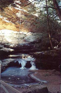
Queer Creek almost frozen. Photo: Connie Pond.
6. Leave SR 56 turning right along trail to Youth Group Primitive Campground. Leave campground along access road. Continue north, generally paralleling SR 374.
7. Cross SR 374 over Queer Creek, near the entrance to Cedar Falls. Continue north along footpath through stands of hemlock trees.
8. Continue north through Virginia Pine forest past access trail to Rose Lake. Descend and cross small creek before reaching SR374/664 and your starting point.