Stockport Section
- Overview
- Akron
- Bedford
- Belle Valley
- Bowerston
- Burton
- Caesar Creek
- Defiance
- Delphos
- Loveland
- Massillon
- Medina
- Mogadore
- New Straitsville
- Norwalk
- Old Man's Cave
- Pemberville
- Road Fork
- St. Marys
- Scioto Trail
- Shawnee
- Sinking Spring
- Stockport
- Troy
- West Union
- Whipple
- Williamsburg

Trail Description
New BTA Trail in AEP
Herb and Susie Hulls
Supervisor: Karen Fisk and Richard Morgan
•
58.1 Total Miles / 19.1 Off Road Miles (32.9%)
Map Publication Date: August 2014
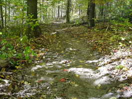
Almost all of the Stockport section is hilly and timbered with small to medium farms scattered throughout. About three fourths of the trail follows township or back roads that are little used. The 18 plus miles of off road trail through former American Electric Power ReCreation lands, but now part of ODNR's Jesse Owens State Park, is an enjoyable hike where many lakes and beaver dams can be seen. Camping and water are available at various sites within the State Park. Other off road sections are around the villages of Stockport and Chesterhill. The historic town of Stockport is very nice with some stores and restaurants plus the beautiful Muskingum River with tables and pit toilets at the bridge. The few towns the trail passes through are small but nice with small stores.


Trail Alerts
- (3/24/22)Trail Alert
This alert adds additional information to the 8/31/20 alert and change below.
Bicentennail Campground (K) is open and managed by the Ohio Department of Natural Resources (ODNR), Division of Wildlife in the Appalachian Hills Wildlife Area. It is located on the BT and is just north of Belle Valley Pt 31 or Stockport Pt 1. No permit is required.
In addition, Wood Grove Campground (H) has now been closed permanently. - (8/31/20)Trail Alert and Change
In October 2019, Ohio Governor Mike DeWine announced an agreement between the Ohio Department of Natural Resources (ODNR) and American Electric Power (AEP) to secure more than 41,000 acres of what had been known as AEP ReCreation Lands and place that land into the public trust in perpetuity. Its administration has been divided between ODNR’s Division of Parks and Recreation and its Division of Wildlife. Division of Parks and Recreation has named their new park as Jesse Owens State Park, now contains 2,794 acres. Division of Wildlife has named their new wildlife area as Appalachian Hills Wildlife Area. At 20,672 acres, it already is the largest wildlife area owned by the Division of Wildlife. By Jan 31, 2021, it will have grown to 38,414 acres. ODNR seeks to acquire the funds necessary to purchase the remainder of the ReCreation Lands.
BTA considers itself fortunate that the entirety of the trail that once was within the ReCreation Lands, 24.4 mi, remains intact and now is within Appalachian Hills Wildlife Area. This trail extends between Pt 27 in the Belle Valley Section and Pt 6 in the Stockport Section.
Division of Wildlife has been working with AEP to help maintain rules regarding hunting, fishing and trespass. I suspect that no hiker will notice much change along the trail. However, with such a major change in ownership, changes should be anticipated. We will try to keep you up-to-date as we become aware of changes.
Following the transfer, fewer campsites remain open. At this time, Bicentennial Campsite (Campsite K), Hook Lake Campsite (Campsite A), Maple Grove Campsite (Campsite G), Sand Hollow Campsite (Campsite C) and Sawmill Road Campsite (Campsite D) are available. All campsites are operated by the Division of Parks and Recreation. Use of the campsites is still free. However, only Bicentennial is located on the BT and is just north of Belle Valley Pt 31 or Stockport Pt 1. The campground, formerly known as Wood Grove or Campground H and located near Stockport Pt 3, has been closed. The closure is probably permanent.
Map Updates
- (3/24/22)Map Update
Wood Grove Campground (H) has now been closed permanently.
Additionally, Bicentennial Campground (K) is open and is now managed by the Ohio Department of Natural Resources (ODNR), Division of Wildlife in the Appalachian Hills Wildlife Area. It is located on the BT and is just north of Belle Valley Pt 31 or Stockport Pt 1. No permit is required. - (3/31/21)Map Update
In the Camping Facilities Section of Stockport Section Map dated August 2014, there is an update for the contact number for Jay Stout who allowed the BTA to build a shelter on his property which lies between Points 6 and 7. Please contact Jay at 740-525-3204 at least 1 day before you expect to camp there.
- (5/28/19)Map Update
We have been alerted that some of the names of roads within the Stockport Section are incorrectly reported. The material below updates the last map version published, August 2014, for Points 7 through 14. This range includes the roads that were misnamed.
CW CCW Pt 19.4
S38.7
N7. McMannis-Riggs Rd (T946) at Onion Run Rd (T232)
The material about The Wilderness Loop is essentially correct and has been omitted.
Exit McMannis-Riggs Rd. Go S on Onion Run Rd that will cross Onion Run 3 times, twice on permanent, high-water fords. After 0.7 mi, Onion Run Rd ends. Join Slivka Rd that continues generally S, more-or-less parallel to Onion Run, until it reaches Meigs Creek. There, continue on Slivka Rd, generally W.21.1
W37.0
SSE8. Slivka Rd (C106) at N Unionville Rd (C11)
Slivka Rd ends here. Head W on N Unionville Rd across Meigs Creek.
After 0.12 mi, N Unionville Rd ends. Turn NW onto SR 60. After 0.2 mi, exit SR 60 W onto Hooppole Ridge Rd (C11) across Perry Creek (250'). Soon, begin a 200' climb up the ridge ahead.22.0
SE36.10
NE9. Hooppole Ridge Rd (C11) at Cooper Ridge Rd (T233)
Exit Hooppole Ridge Rd SE onto Cooper Ridge Rd (T233). After 1.2 mi, pass Cooper Ln (T691, exits ENE). Continue E on Cooper Ridge Rd that turns slowly S and descends.23.5
W34.6
N10. Cooper Ridge Rd (T233) at Olney Run Rd (T150)
Cooper Ridge Rd ends here. Turn W onto Olney Run Rd that slowly ascends in the valley of Olney Run.25.8
S32.3
E11. Olney Run Rd (T150) at Groah Rd (T176)
Exit Olney Run Rd S onto Groah Rd across Olney Run (25'). Begin rather steady 230’ climb.26.7
NW31.4
NE12. Groah Rd (T176) at Point Lookout Rd (C36)
Groah Rd ends here. Turn NW onto Point Lookout Rd (C36). After 0.6 mi, right after Point Lookout Rd makes a hard turn S, Point Lookout Rd ends in an extended 3-way intersection. Keep S on McCoy Ridge Rd (C6) along Patterson Ridge.28.2
S29.9
N13. McCoy Ridge Rd (C6) at Patterson Ridge Rd (T181)
Exit McCoy Ridge Rd that here turns hard E. Continue S now on Patterson Ridge Rd as it descends from Patterson Ridge past small octagonal house into Henry Hollow, a drop of about 275’.29.9
NW28.2
NE14. Patterson Ridge Rd (T181) at Bebout Rd (C6)
Patterson Ridge Rd ends here. Turn WNW onto Bebout Rd. After 0.7 mi where Bebout Rd ends, turn SW onto SR 376 (unmarked). After 0.35 mi, just past a service station (MM), pass the drive that leads to Lock 6 Park (P, Pr, PT, Ws) on the Muskingum R Improvement, which comprised a system of 11 locks and dams that made the Muskingum R navigable from Marietta to a short feeder canal just south of Dresden, OH, that connected to the Ohio and Erie Canal. Very soon, turn WNW onto SR 266. After 0.14 mi, pass above Lock #6 Park (easy access on foot by dropping over the grassy embankment).31.3
NW26.8
NE15. Broadway (SR 266) at Market St (C2) in Stockport
- (7/1/17)Trail Change
This trail change alerts you to a condition that you may notice between Points 24 and 25 on your Stockport Section Map, Edition of August 2014. Newburn Road or Drive, which connects Points 24 and 25, has been decommissioned. In addition, the road at the west end is blocked by logs with signs marked “Closed” or “Private.” There is no change in access, distance, or directions. However, because maintenance is no longer the responsibility of Morgan County and road conditions may deteriorate as a consequence, we added the coordinates of the two points and noted that the route crosses Goshen Run twice and an intermittent tributary once.
CW CCW Pt 47.8
NW10.3
SE24. Hoffman Rd (T55) at Newburn Rd
This intersection is located at 39.52438N, 81.89452W. Although Newburn Rd has been decommissioned, BTA has permission by easement to continue hiking along this road which follows Goshen Run. Exit Hoffman Rd. Head generally W on Newburn Rd. There are several fords along the road; Goshen Run (0.20 mi), an intermittent tributary to Goshen Run (0.30 mi) and Goshen Run ( 0.19 mi) again.48.7
N9.4
E25. Newburn Rd at Wood Rd (C53)
The location of this point is 39.52301°W, 81.90936°N. See information at Pt 24. Turn N on Wood Rd. Return to the trail description in your current Stockport Map. - (8/25/14)Trail Updates for Stockport
This Trail Change supersedes the Trail Change dated 11/18/13. It updates the Stockport Section Map dated January 2013 to include the loss of off-road trail between Pt 6, BT at McMannis-Riggs Rd (T946), and Pt 7 as defined on the January 2013 map as well as the recent return of the trail to the Williams Covered Bridge.
The changes near McMannis Riggs Road are described first. Distances are somewhat different due to a more recent survey of the trail between Pt 3 and Pt 4. Note that Pt 7 is redefined below as “McMannis-Riggs Rd (T946) at Onion Run Rd (T232)”. Note also that a new campsite has been added between Pt 6 and Pt 7. Details follow. “Between Pt 6 and Pt 7, Jay Stout permitted BTA to construct a shelter that is free to the hiking public. Contact the Stouts at least 1 day before you expect to be there at either 304-210-7728 or 740-525-5784 to let them know that you will be there.”
The changes near the Williams Covered Bridge are described next (Pt 18, Pt 19 and Pt 20.) Some of the former off-road trail in the vicinity has been lost but some has been restored.
Finally, see the table that shows the current point numbers, clock-wise and counter clockwise distances and the location of each point.CW CCW Pt 16.6
S41.5
N5. Culvert across McMannis-Riggs Rd (T946)[39.653733°N, 81.699633°W]
BT fords Onion Run twice in this segment. If you see evidence of unusually high water, you may want to follow McMannis-Riggs Rd W to Pt 6.
Follow BT S through woods and open fields. After 2 mi, ford Onion Run a second time and soon (0.12 mi) reach McMannis-Riggs Rd.18.5
S39.6
N6. BT at McMannis-Riggs Rd (T946) [39.632467°N, 81.698744°W] 19.4
SW38.7
N7. McMannis-Riggs Rd (T946) at Onion Run Rd (T232)
Here is the junction with a blue-blazed loop trail that is called The Wilderness Loop (TWL) for its pleasantly undeveloped nature. TWL comprises a loop that joins NCT in Wayne National Forest in Monroe and Washington Counties with BT in AEP ReCreation Land. TWL E (CCW) from here is described first in the WHIPPLE SECTION and later in the ROAD FORK SECTION. The description is completed in BELLE VALLEY SECTION (Pt 25 to Pt 30) and STOCKPORT SECTION (Pt 1 to Pt 7). TWL is 145.2 mi long, a distance that includes 57.1 mi off road. Few services will be found along the route.
Go SW on Onion Run Rd SW across Onion Run (0.2 mi). After 0.4 mi where Onion Run Rd ends, turn S onto Slivka Rd (C106).a 36.1
NW22.0
NE18. Lightner Ridge Rd (T22) at Tabor Ridge Rd (C66)
Lightner Ridge Rd ends. Go NW on Tabor Ridge Rd past Newman Lane (0.11 mi, T28A, exits W) and Cain Ln (1.0 mi, T49, exits NE).38.3
S19.8
E19 Tabor Ridge Rd (C66) at Goshen Run Rd (C52)
Tabor Ridge Rd ends. Go S on Goshen Run Rd, descending slowly through remote rural land. After 1.5 mi where Goshen Run Rd turns W, go E on Williams Bridge Rd.40.2
W17.9
E20 Williams Bridge over West Branch Wolf Creek
Long known as the Barkhurst Mills Covered Bridge, this bridge is known today as the Williams' Bridge. The bridge was built in 1872 by John Shrake, then one of central and southeastern Ohio's foremost bridge builders. The mill for which the bridge is named stood about 75 feet away on the north side of Wolf Creek. The bridge is built with multiple king post trusses, a system of upright posts with diagonal braces widely used for construction of wooden bridges in Ohio during the 19th century. Go W on Williams Bridge Rd (C21). After 0.5 mi where Williams Bridge Rd turns S, join active skid road that climbs through private land past old barn w/Pr to Sandy Lane. Continue W. After 0.5 mi, merge onto SR 377 and go S past Buckeye Ridge Rd (0.45 mi, C7, exits S). Sidewalk is now available on E side of SR 377.
Current Point numbers, distances, and locations:
| CW | CCW | Pt | |
|---|---|---|---|
| 0.0 | 58.1 | 1 | Lincoln Highway Rd (T13) at Hedge Rd (T2) |
| 3.8 | 54.3 | 2 | Trail Junction near SR 78 |
| 6.5 | 51.6 | 3 | Wood Grove Rd (C27) Crossing just S of Campsite H |
| 12.9 | 45.2 | 4 | BT at SR 78/SR 83 near Bridge over Dyes Fork (P) |
| 16.6 | 41.5 | 5 | Foot Trail on ATV Trail at McMannis-Riggs Rd (T946) W of Culvert |
| 18.5 | 39.6 | 6 | BT at McMannis-Riggs Rd (T946) |
| 19.4 | 38.7 | 7 | McMannis-Riggs Rd (T946) at Onion Run Rd (T232) |
| 21.1 | 37.0 | 8 | Slivka Rd (C106) at Unionville Rd (C11) |
| 22.0 | 36.1 | 9 | Hooppole Ridge Rd (C11) at Cooper Ridge Rd (T233) |
| 23.5 | 34.6 | 10 | Cooper Rd (T233) at Olney Run Rd (T150) |
| 25.8 | 32.3 | 11 | Olney Run Rd (T150) at Groah Rd (T176) |
| 26.7 | 31.4 | 12 | Groah Rd (T176) at Moore Point Lookout Rd (C36) |
| 28.2 | 29.9 | 13 | McCoy Ridge Rd (C6) at Patterson Ridge Rd (T181) and McCord Ridge Rd.(C6) |
| 29.9 | 28.2 | 14 | Patterson Ridge Rd (T181) at Bebout Rd (C6) |
| 31.3 | 26.8 | 15 | SR 266 at Market St (C2) in Stockport |
| 32.7 | 25.4 | 16 | Salt Works Hill Rd (T23) at SR 792 |
| 24.7 | 23.4 | 17 | Starling Lane (T 23A) at Lightner Ridge Rd (T 22) |
| 36.1 | 22.0 | 18 | Lightner Ridge Rd (T22) at Tabor Ridge Rd (C66) |
| 38.3 | 19.8 | 19 | Tabor Ridge Rd (C66) at Goshen Run Rd (C52) |
| 40.2 | 17.9 | 20 | Williams Bridge over West Branch Wolf Creek |
| 42.5 | 15.6 | 21 | SR 377 at SR 555 in Chesterhill |
| 43.5 | 14.6 | 22 | Henman Rd (T53) at Thomas Rd (C82) |
| 45.3 | 12.8 | 23 | Thomas Rd (C82) at SR 555 |
| 47.8 | 10.3 | 24 | Hoffman Rd (T55) at Newburn Rd (T58) |
| 48.7 | 9.4 | 25 | Newburn Rd (T58) at Wood Rd (C53) |
| 50.4 | 7.7 | 26 | Wood Rd (C53) at Westland Rd (C39) |
| 52.0 | 6.1 | 27 | Westland Rd (C39) at South Elliott Rd (C4) |
| 53.5 | 4.6 | 28 | Wells Rd (T102) at Miller Rd (C101) and SR 555 |
| 54.8 | 3.3 | 29 | Miller Rd (C101) at Rock Hollow Rd (T67) |
| 55.9 | 2.2 | 30 | Rock Hollow Lane (T67) at Van Horn Hill Rd (T110) |
| 58.1 | 0.0 | 31 | SR 78 at East Branch Church Rd (C58) |
- (11/18/2013) The email address for a free permit for AEP Ohio ReCreation Lands is http://www.aep.com/environment/conservation/recland/pdf/PERMIT.pdf.
Trail Towns
- There are no Trailtowns in this Section at the present time.
Section Blogs
- (4/22/24) The Buckeye Trail Reveals Gems in the Stockport Section, provided by Victoria Livingston, BTA hiker. Who stole all those road and business signs? This can’t be Morgan High School! Stockport reveals hidden gems to Buckeye Trail hikers. This is another reason why The Buckeye Trail is a journey, not just a race to accumulate miles.
- (4/22/24) Misadventures in a Stockport Extreme Driving Challenge and Vindictive Vegetation The Stockport Section of the Buckeye Trail, Points #21-27, presented an extreme driving and hiking challenge with water crossings on one-lane, muddy, rutted roads. Roxanna got freezing feet. Then, Sawman (Dave) got attacked by a nasty grapevine. Provided by Victoria Livingston, BTA hiker.